
By Rex Weyler
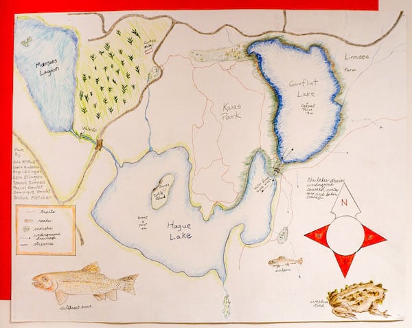
These maps were created by a Cortes homeschool science class with instructor Rex Weyler and students: Angus Ellingsen, Seren Anderson, Fergus Walker, Lara Huuskonen, Nathanial Hargrave, Joshua Fletcher, Nola McPhail, Ezra Ellingsen, Seamus Summers, Pascal Goulet, and Dominique Goulet.
We were studying Hague and Gunflint lakes, the water flow through the lakes, the flora and fauna, nutrient cycles, and the bloom of algae, diatoms, and other organisms. We were interested in learning about the risks to the community of extreme algae blooms, the cause factors of the blooms, and prevention actions that the community could take. Following examples from other regions, we planted some cattail in the lake, which still exists and is spreading slowly several years later.
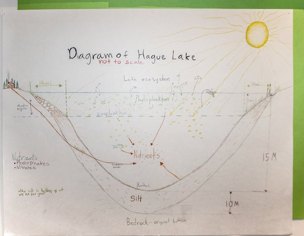
The lakes are always in process, in annual, seasonal, and long-term cycles and transitions. For example, the sediment falling to the bottom of the lakes has been building up at about 1 mm/year for some 10,000 years, so there are about 10 metres of sediment on the bottom of both lakes. We learned by experiment that sometimes water is flowing in both directions through the channel (currents at different depths) between the two lakes. Algae and diatom blooms occur every spring and summer as certain conditions change: nutrient load, air and water temperature, oxygen saturation, and so forth. Our class worked with Friends of Cortes Island (FOCI) to measure and monitor some of these factors.
We drew the elevation map of Hague Lake at accurate scale, to emphasize how delicate and shallow these lakes actually are. The lakes can be seen as an exposed section of the vast water tables on the southern end of Cortes, so the water flows into and from the lakes through many underground passages, as well as through the open streams. The lakes empty into Mansons Lagoon to the west, but also into the lowland bogs to the southeast, which drain through Hank’s Beach and into Cortes Bay.
